
The Oleron path
Walking immersion on an island of surprising nature!
![]()
Discover the island of Oléron on foot along the 105 km of hiking trails on the Chemin d'Oléron. Along the way, you'll pass through a wide variety of landscapes. Between ocean, marsh and forest, you'll have plenty of time to discover the island's exceptional flora and fauna. Here's a new way to discover the island. To the sound of the gravelot, let your steps carry you from the pointe de Gatseau to the Chassion lighthouse, from the port of Boyardville to that of La Cotinière.
This trail was developed thanks to an exemplary collaboration between the Communauté de Communes de l'ile d'Oléron, the Office du Tourisme de l'ile d'Oléron et du bassin de Marennes, the Département de Charente-Maritime, the Office National des Forêts, the Conservatoire du Littoral and local associations: l'association IODDE, la mission natura2000, la Direction Département des Territoires et de la Mer, l'Université du Temps Libre, le Comité Départemental de Randonnée Pédestre, l'association des Sports Dyonisien, l'association OLERANDO, le Comité Régional de la Conchyliculture and the communes.
Le Chemin d'Oléron: a low-carbon holiday in New Aquitaine

The "Séjours bas-carbone en Nouvelle-Aquitaine" (low-carbon holidays in New Aquitaine ) offer you the chance to (re)discover destinations in France's largest region, via a selection of original, committed and meaningful experiences. Guaranteeing tourism that is mindful of its environmental, social and economic impacts, these stays offer the promise of exchanges with locals and encounters with professionals whose commitment to responsible tourism and sense of hospitality make New Aquitaine a unique territory.
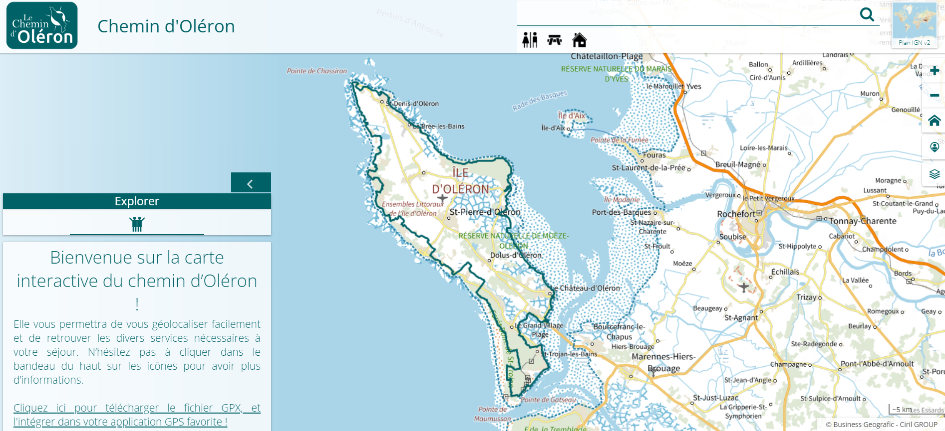
Access the interactive map of the Chemin d'Oléron and geolocate yourself by clicking here!
You can also consult the complete itinerary of the Chemin d'Oléron on our Loopi application.
Or see the complete itinerary by clicking here.
September to November and February to May are particularly good months for hiking on the island of Oleron. In fact, if you're dreaming of discovering the Ile d'Oléron in a different way, check out Gregory Rohart's full article on I-Trekkings for all the details on this unforgettable experience.
Before you set off to discover the island and its treasures, remember to prepare your stay, book your accommodation and prepare your equipment. You're free to organize your journey as you wish, or to follow the five- or seven-stage itinerary suggested on the Chemin d'Oléron map. See below for details of what you can discover along the way.
Please note that Oleron beaches are now litter-free. After your breaks, you'll need to take your garbage with you to your next accommodation.
Transport at your disposal
The nearest train stations are Rochefort, Surgères and La Rochelle. From the station, you can take a bus to Château d'Oléron, where you can start the hiking trail.
The island of Oleron is accessible by boat part of the year from the port of La Rochelle to the ports of Saint-Denis d'Oléron and Boyardville, from where you can begin your tour.
For more information, visit our access page: click here!
Luggage or personal transport: if you require transport services during your stay on the Chemin d'Oléron, don't hesitate to contact PasSsages, based in La Brée-les-Bains, on 06 26 79 87 03 or by e-mail passsages17@gmail.com in advance of your visit to plan your travel arrangements.